
Walk a Maple Valley Street
A useful Maple Valley street directory search follows records in a set order. King County GIS first converts a street string into a parcel identity. The assessor then reports the taxpayer or owner, the situs address, the mailing address, and the legal description. Situs means the physical location of the parcel. It is not the same as the address where tax mail goes. Neither field proves who sleeps in the home. Recorded deeds establish transfers of an interest in land, while voter and directory evidence can only support a careful conclusion about residence.
- Enter the full address in King County Parcel Viewer and save the ten-digit PIN, jurisdiction, and legal description.
- Open the linked eReal report. Compare the owner or taxpayer, situs address, mailing address, sale history, and building facts.
- Browse adjoining parcels on the same road. Use map selection only as a navigation tool, not as a legal survey.
- Search Landmark with the PIN and party names. Check roles, recording dates, numbers, and legal descriptions.
- Use a voter lookup only for a known person. For older occupants, check the appropriate reverse-directory edition and census year.
Write down the date and source beside each name. A current parcel card, an older deed, and a directory entry describe different moments. Keeping them separate prevents an earlier owner from being presented as a current Maple Valley resident.
Maple Valley Parcel Search Fields
The King County eReal Property system and Parcel Viewer are the strongest first stops for a street directory. They accept an address or parcel number, while eReal also documents an owner or property-name route. Parcel Viewer can search a condominium name, open a parcel summary, and link to assessor and district reports. Exact labels can change as the county updates its interface.
| Search control | Input | How it helps |
|---|---|---|
| Address | Street text | Resolves the situs to a mapped parcel |
| Parcel or PIN | 10 digits | Connects GIS, assessor, map, and recorded-document work |
| Owner/property name | Name text | Finds assessor property records when a name is known |
| Condo name | Name text | Locates a condominium in Parcel Viewer |
| Select parcels | Line or area tool | Builds and exports a small parcel set |
| Layers | Map toggles | Shows zoning, address points, and district conditions |
The report may contain parcel and legal identity, land use, lot size, buildings, values, sales, and exemptions. Read owner and mailing data with care. The taxpayer can live elsewhere, and the street directory cannot turn a tax record into a complete household list.
Maple Valley PINs Unlock Records
Land records work better with a PIN than with a street name. King County uses major and minor digits: the first six generally identify the plat or subdivision, and the last four identify the parcel. Special values such as ROAD, TRCT, UNKN, and condominium 0000 can appear where a result does not resemble a standard home parcel. A legal description is the formal land identity, often based on subdivision and lot or on metes and bounds.
- Parcel
- A mapped unit of land with a county identifier.
- Situs address
- The physical address assigned to the property.
- Plat
- A recorded map that divides land into lots, roads, or tracts.
- Criss-cross directory
- A historical volume arranged by address or street instead of only by surname.
This is the key insider step: convert the Maple Valley address to its PIN and legal description before opening the Recorder index. Landmark does not offer a simple modern street-address field for every recorded document. The formal land keys bridge a current address to older filings.
Maple Valley Records by Address
Several official sources can be walked by address, but they answer different questions. The assessor and map show parcels. The Recorder documents recorded interests. County permits cover unincorporated land, while city permit and code files may require a Maple Valley public-records request. My Voter verifies a known voter and is not a street roster.
| Record Set | Keeper | What It Shows | Access |
|---|---|---|---|
| Property roll | King County Assessor | Owner, mailing and situs addresses, building and value facts | Free eReal report |
| GIS parcel map | King County GIS | Parcel shapes, nearby lots, zoning, address points | Free viewer; not a survey |
| Recorded documents | King County Recorder | Deeds, liens, plats, easements, and named parties | Landmark mostly August 1991 onward; older microfilm |
| Permit files | King County or Maple Valley | Work, application, status, and inspection clues | County Accela from 1996; city PRA fallback |
| Voter records | King County Elections / SOS | Known-person match or approved file categories | Restricted by Washington law |
| Reverse directories | Libraries and archives | Historical address-to-occupant entries where covered | Selected digital, licensed, or on-site editions |
The PIN joins the first four sources. Names and dates then help match a deed to an assessor sale or permit. A street spelling joins historical sources only after older community labels and road forms have been checked. Note: Maple Valley postal identity does not by itself establish city permit jurisdiction.
Browse Maple Valley Parcels
Parcel Viewer supports the literal street-by-street part of the search. Turn on parcel boundaries and address points, zoom to a road segment, and click each lot that fronts it. The line or area selection tool can collect a short run and export selected data. Zoning and district layers add context, while aerial and topographic basemaps help orient the search.
The official map warns that it gives general location only, can change, and is not a survey. Corner contact also does not always mean two lots share meaningful frontage. For a boundary question, consult the recorded plat or survey in Landmark. For resident research, record each lot's PIN, situs, jurisdiction, and report link before moving on.
The official Parcel Viewer screen shows the address and parcel tools used in a Maple Valley street directory search.
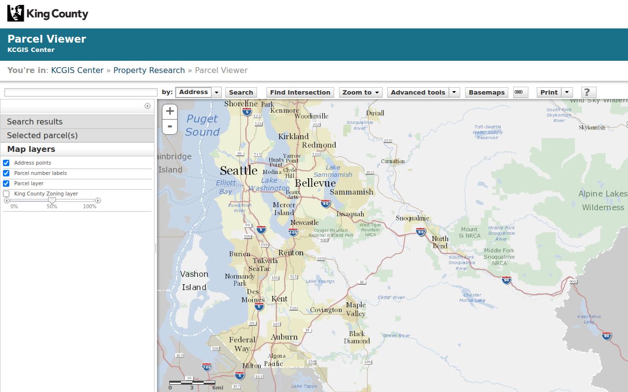
Its parcel-first layout explains why the map can identify mapped owners and lots, but cannot supply a list of everyone living along the street.
Maple Valley Street Deed Trail
After finding the PIN, open Landmark Records Search. Most documents recorded on or after August 1, 1991 are online. Parcel searches chiefly reach 1997 to the present and use the first ten digits. Earlier documents are generally on microfilm at King County Archives, so an empty online result does not end the street directory search.
Landmark accepts party name in Last, First form, document type, book and page, consideration, parcel ID, recording date or number, legal description, and Torrens number. Grantor is the party giving an interest; grantee is the party receiving it. Results can show parties, instrument type, recording date and number, and an image link. An online image is unofficial, and some images are withheld or unavailable.
Use the Recorder copy-order route for an uncertified or certified copy. The counter at 201 S Jackson Street, Suite 204 in Seattle is open weekdays from 8:30 a.m. to 4:30 p.m.; phone help is available at 206-477-6620 on weekdays from 9 a.m. to 2 p.m. Mail requests use the same address. Staff can search named parties, document types, and years for a fee, but they do not conduct a title search by phone or email.
Maple Valley Permits by Street
The King County Accela portal accepts address, parcel, and permit number for unincorporated property. Public users can view status, details, and inspection results without signing in. Online application and completion history generally begins in 1996. A permit names an applicant or project contact in an official file, not every person who used the property.
City limits change the keeper. Research did not verify a complete Maple Valley permit portal field list, so city permit or code files should be requested from the City Clerk under the Washington Public Records Act. The city incorporated in 1997. Older files may remain in King County custody or be arranged under a rural community or county parcel identity.
Maple Valley Voters Aren't a Roster
King County My Voter Information asks for any three of first name, last name, date of birth, and house or building number. It verifies a person already known to the searcher. It has no public browse-by-street mode, so it cannot serve as the Maple Valley street directory.
The lawful broader route is Washington's voter database extract, subject to RCW 29A.08.720, RCW 29A.08.740, and the anti-commercial-list restriction in RCW 42.56.070(8). Protected addresses can be withheld. Washington's Address Confidentiality Program also lets qualifying people use a substitute address. An absent or different address may therefore be a designed safety measure rather than a bad record.
Older Maple Valley Street Names
Maple Valley became a city on August 31, 1997, but its record trail is much older. Search older directories, newspapers, and census materials under Cedar River, Hobart, Tahoma, Kent, Renton, Black Diamond, rural-route wording, and the early Vine Maple Valley name. A current postal city should never be pushed backward into a record created under another jurisdiction.
Reverse directories can connect an address to a named occupant when the edition covers the area. Seattle Public Library identifies a digitized 1928 House and Street Directory and says reverse address listings began in 1938. County and Seattle Suburban South runs may help, but Maple Valley coverage must be checked edition by edition. The complete shelf belongs on the Maple Valley city directories page.
Limits of Maple Valley Street Records
No Maple Valley street directory can reliably list every renter, child, guest, or other household member. Utility customers, DMV addresses, protected voters, and the real addresses of Address Confidentiality Program participants are outside an ordinary public street search. Assessor data establishes a tax or ownership association. A deed records a legal transaction. A permit documents work. Even a directory entry reflects a publication-time link, not a permanent fact.
Use at least two records with matching names, dates, and land identity before drawing a conclusion. Keep an older owner separate from a current occupant. If accuracy matters, obtain the official copy from the custodian and preserve the source date.
Lawful use. Maple Valley address records support family history, property research, civic review, and personal safety. Never use them to stalk, harass, intimidate, or harm anyone.